
This film was created to promote this post; however, the material itself was generated over three years ago.
The creation of this short clip was inspired unconsciously by one person. It was a client who, in the past, wanted a specific building to be placed in a specific location and wished to see how it would look. This is not the same building shown in the clip, although it was modeled from scratch according to the project guidelines. I am not publishing it solely for privacy reasons. I can only mention that it was a building of similar proportions, intended to be placed on a relatively small and mountainous plot in Wieliczka near Kraków. The original project was created according to the architect’s guidelines, with precise coordinates and a specific location provided.
The film presented in this post shows a similar version of how such a commission is developed. There is only one small difference: the terrain shown here is a product of my imagination, whereas the terrain from Wieliczka is a faithful representation of elevation data obtained from the geoportal.gov.pl website. Using this portal, we can accurately recreate a realistic state of a given area with the help of QGIS software, provided that the elevation data available on the national geodetic website has been properly prepared. Additionally, satellite imagery as well as building outlines (LOD1) or even more detailed building volumes (LOD2 – Level of Detail) can be incorporated into the project.
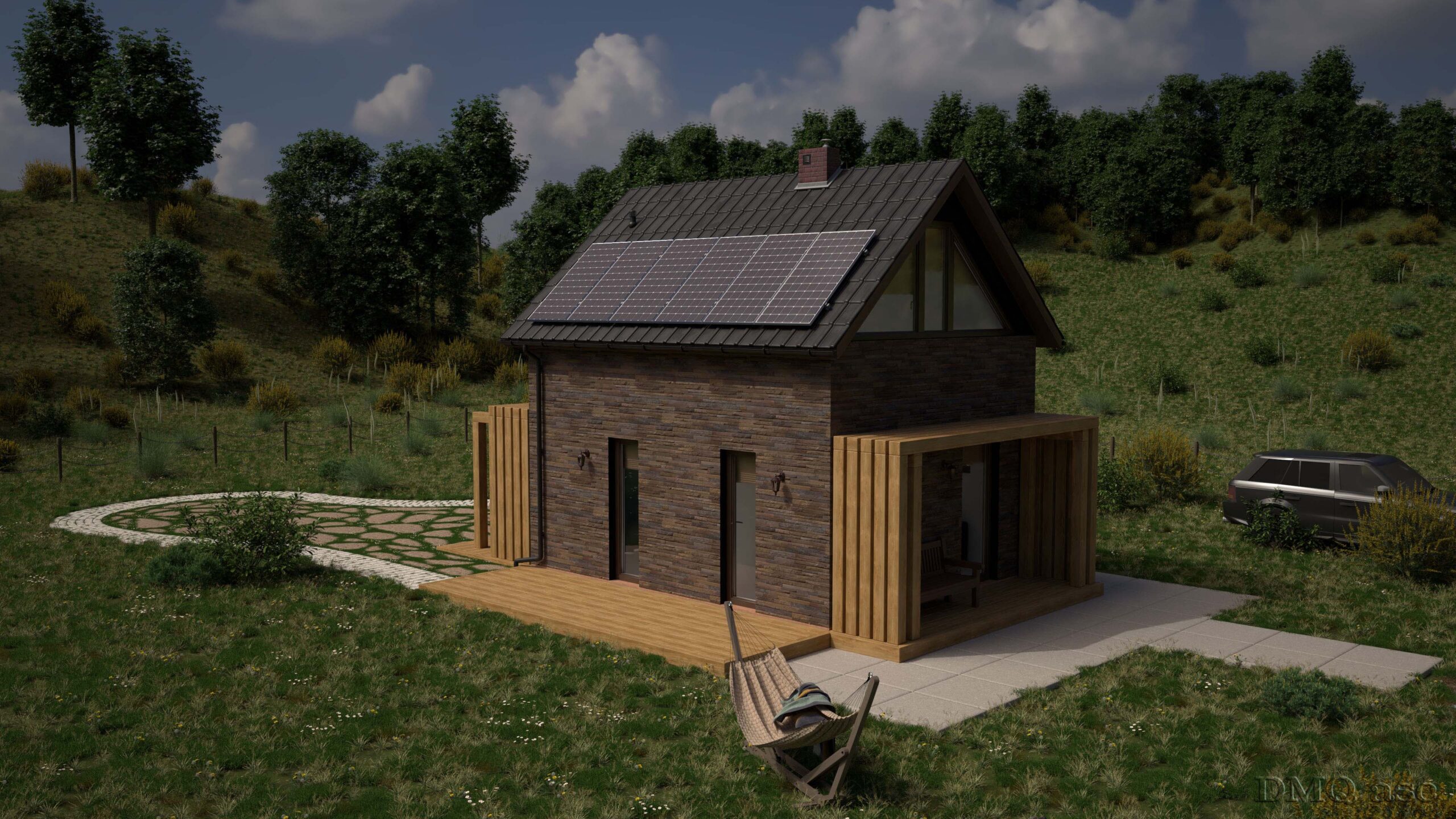
The film shows the stages of terrain visualization as well as changes in weather and time of day. In the initial phases, changes result from land development. The house was created next to a small pond, while the terrain itself undergoes transformation. It was divided into four sections depending on the type of vegetation covering it. Randomly distributed grasses, flowers, and trees were placed sequentially; these are ready-made proxy model files to avoid overloading the scene. These stages were applied once, while the final result is presented from four different camera angles. Additionally, the terrain was equipped with a modeled imitation of fencing based on wooden stakes connected with a chain, as well as a library of ready-made models such as a car, bicycle, hammock, and firewood for a campfire.
The final environmental effect was enhanced with lighting conditions, including sunny weather, light morning fog, an evening atmosphere, and advanced dusk lighting. Weather effects such as rain or snow, as well as sun movement, could also be added; however, due to the fictional terrain layout, this aspect was completely omitted.
The film was created from a compilation of 12 shots taken from four different camera frames, using morphing transitions to visually emphasize the presentation.
The house itself is a real architectural form sourced from Archon’s resources (link below), but with a completely modified façade, as requested, and additional exterior wall lights. At this stage, the interior was modeled but not finished with details, which is why the house appears empty inside. Ultimately, the interior was completed by the company Wzornik Projektowy, while my task was to focus on the exterior appearance and visualization according to the client’s specific request.
In the future, I plan to present on a non-commercial basis a specific building model placed on a real, existing terrain, using the aforementioned elevation data techniques sourced from the geoportal service.
The clip includes selected details such as solar panels, roof tiles, and a chimney. These elements were modeled according to real parameters and materials available on the market over three years ago.
The film features background music generated by AI in Suno and includes the presentation of the logos of the two companies involved in the project.
If you are planning to place a specific house on a specific mountainous plot and would like to present it for promotional purposes either for my company or to showcase visualization capabilities please send me the data by email along with your consent. In the future, I will create such a project and, due to a lack of predefined concepts, will use randomly selected material.
The project was created in the software I know very well SketchUp and the photorealistic shots were rendered in V-Ray. However, due to a change in the software I currently use, new material will be created exclusively in Blender.
I encourage especially those who are planning to build a house, or who already have one at a very early stage, to try this method as a non-commercial presentation on my forum and later on the website blog.
Link to the original house design project:
https://www.projektydomownowoczesnych.pl/p,mb2025784aa9e9,domek-letniskowy-w-cienistkach-2-ver-2
This is admittedly a very old 3D model project, but newer models will gradually appear, including those based on photogrammetry systems, such as LiDAR point cloud scanning or Gaussian splatting. These methods allow for the presentation of a 3D form without the need for traditional scanning, relying instead on video recordings or orbital image sequences of the model captured under diffuse lighting conditions.
The selected images illustrate my ability to modify and enhance the visual effect of a person, object, or landscape based on original source material. The final result is subjective and reflects a specific moment in time. Each of us perceives things differently and operates within a different time frame and skill set. The regularly published posts featuring specific themed projects are intended to systematically collect materials that showcase graphic capabilities.
Enjoy watching!